Adapting to Heavy Rains in Western North Carolina
STEP 1: IDENTIFY THE PROBLEM INCLUDING STRESSORS AND IMPACT
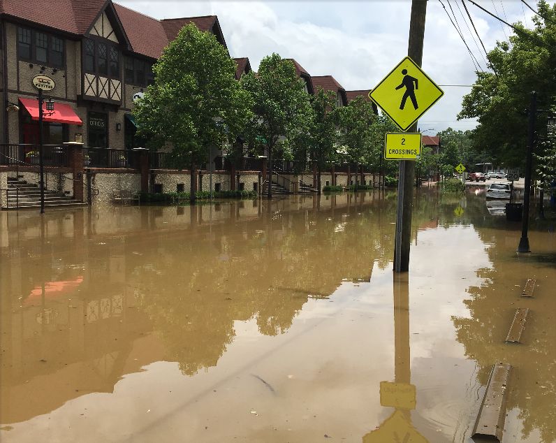
In September 2004, Western North Carolina was significantly impacted by floods and landslides caused by two major hurricanes. The cost was high. Eleven lives were lost, 140 homes were destroyed and more than 16,000 homes were damaged in the Asheville area and surrounding counties. In total, there were $200 million in damages and freshwater supply was lost to Asheville for several days due to erosion and a break in the water main. These types of severe storms are not unusual in Western North Carolina. In Asheville alone, nine major floods have occurred in the past 100 years, two of the most serious in 1916 and 2004. Damaging floods occur every 20 years on average. Future storms and flooding events have the potential to cause more property, infrastructure damage and loss of life. Garnering support and building the team: After the 2004 floods, a Flood Damage Reduction Task Force (FDRTF) was formed which included the City of Asheville, Buncombe County, Universities, local businesses, non-profit organizations, and other local, county, and state agencies. A planning study was also conducted by the North Carolina Department of Environment and Natural Resources Division of Water Resources and stakeholders from Biltmore Village, the City of Asheville, and the Swannanoa Watershed with assistance of a project consultant.
STEP 2: ASSESS YOUR RISKS AND VULNERABILITIES
The FDRTF identified known risks and vulnerabilities in the Swannanoa watershed.One known risk was that the Swannanoa River was prone to flood during extreme rain events and the surrounding community including people, infrastructure and homes were vulnerable.
STEP 3: IDENTIFY OPTIONS TO BUILD RESILIENCE
After assessing for risks and vulnerabilities the FDRTF identified 45 potential projects for building resilience by reducing the impacts from flooding in the Swannanoa River watershed.
STEP 4: EVALUATE THE COSTS OF ACTION(S) VS INACTION AND CHOOSE THE BEST OPTION
Potential projects for reducing flood damage were ranked according to their environmental impact, ability to implement and other factors. The ranking highlighted several options for increasing adaptive capacity of the storm water system, including:
- Property buyouts,
- Opening an alternative reservoir for flood mitigation,
- Reconstructing a critical bridge,
- Installing an early warning system
- A flood retention project to manage high water during flood events.
We identified new building regulations in the floodplain to reduce exposure to future flood events.
STEP 5: IMPLEMENT– TAKE ACTION!
All of the projects listed above were implemented. The final flood retention project is still being implemented. Together, the projects are keeping flood waters away from pedestrians, vehicles and housing, which thereby lowers the vulnerability of the community. Partnerships had a crucial role in implementation: An added benefit of the flood retention project is a partnership with the NC Department of Transportation to make improvements, including installation of a traffic signal and turn lane which will benefit users of the nearby Nature Center, Recreation Park and Soccer Complex. The location is also considered as part of an ongoing flood remediation study by the Army Corps of Engineers. The FDRTF worked to raised awareness with the community and sought funding for building community support for the projects. The FDRTF partnered with the local University to provide GIS, education and outreach tools on flood mitigation. Outcomes and monitoring effectiveness A major storm event in the summer of 2013 showed how effective these measures have been to lower vulnerability. July, 2013 was the wettest July on record for Asheville, including three days in the first week of the month that set daily rainfall records. Despite the heavy rainfall events in the Asheville area in July, the Swannanoa River remained below flood stage. The flood retention project for Phase 1 was completed in December, 2014. The Federal Emergency Management Agency (FEMA) announced that the City’s voluntary management activities exceeded the standards of the National Flood Insurance Program (NFIP). Therefore, the outcome is not only a safer community, but also a 10 percent reduction in flood insurance premiums. The NFIP report cites several positive steps taken by the City of Asheville to reduce flood damage, including education and outreach projects, floodplain mapping, preservation of open space in flood prone areas and storm water management, such as the Swannanoa River flood control project.
Additional Resources: