Assessing Climate Vulnerability in Florida
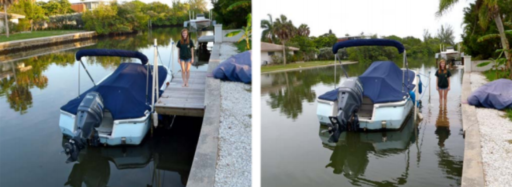
Image of water levels in the 2012 King Tide at Bayou Louise at Siesta Key.
Can this tool help cities and counties make better decisions?
Climate Vulnerability Assessments are viewed by SSDN members as having the potential for great impact in their communities and to influence leaders and policymakers around climate change. Climate vulnerability assessments provide a framework for local decision-makers and government officials to assess a community’s vulnerability to climate change. Furthermore, it provides a selection of methods and tools to assess the different components that contribute to a system’s vulnerability to climate change.
We know that communities are more and more likely to see first hand the effects of climate change now, and so assessing the vulnerability to climate change is important for defining the risks and provides information for identifying measures to adapt to climate change impacts. The data collected in the process helps to identify the most vulnerable areas and populations. In turn, this means climate change adaptation options can be more targeted and the plans can be more specific.
Learn how two SSDN communities are using climate vulnerability assessments in Florida to guide their climate change policies and actions, and make more informed decisions.
City of Fort Lauderdale
The City of Fort Lauderdale participated in a climate vulnerability assessment as part of the Southeast Florida Regional Climate Change Compact which includes four counties and more than 100 cities located in southeast Florida. It works on a variety of climate change issues with and for the region. The Compact held public convenings with the region’s citizens and merged public input with technical analysis to come up with the assessment, which entailed a regional sea level rise report, as well. The results of the analysis produced a Regional Climate Action Plan, which Fort Lauderdale uses as a primary guide for climate action planning and policy creation at the local level.
The assessment and plan allow Glen Hadwen, Sustainability Manager in Fort Lauderdale, to work with his local commissioners to propose and pass policies and develop new practices that specifically target the areas his city will be most vulnerable to climate change. In southeast Florida, rising sea levels often take priority, but Glen is using this regional data and embedding it into every climate action they take, whether it be public infrastructure, stormwater, transportation and more. Glen says that the data allowed them to see things they expected to see, but also to identify new challenges.
“We were surprised to see that a lot of Fort Lauderdale’s flooding happens five miles inland from the coast. We have seven miles of coastline, but over 165 miles of canals,” Glen reveals.
Fort Lauderdale also formed a sustainability advisory board that, together with Glen and other key City staff, meet regularly to assess progress of the plan’s implementation. Internal to the City, the report and planning process has also spurred a group of climate ambassadors of more than 40 cross-departmental staff that have been trained by NOAA to incorporate sustainability work into their daily work. As part of upholding the climate action plan, they report regularly about how their work is contributing positively toward the City’s climate change work.
Fort Lauderdale used the climate vulnerability assessment data to create “adaptation areas” and by doing so, the City is able to implement climate adaptation strategies easily for these designated areas. They identified 16 of these areas, and these are therefore the recipients of capital improvement project funds (CIP) and are prioritized. The City is also applying the assessment to its storm watermaster plan, its water master plan (Fort Lauderdale has its own water utility), and has helped influence the transition of the StormWater Department into the Sustainability Division. The storm water and sustainability team are now looking into an asset management system, which will allow them to look at piping for water and stormwater and assessing the condition and improvement needs. Because they have updated climate vulnerability assessment data, their water and stormwater data can be overlaid with flooding and sea level rise data to best plan for future infrastructure needs, adapted to climate change.
City of Sarasota
The City of Sarasota’s Stevie Freeman-Montes recently completed a climate vulnerability assessment and climate adaptation plan. Sarasota focused strictly on an assessment for city/public infrastructure, which included stormwater, water supply, wastewater and reclaimed water, transportation, parks, and shorelines. Stevie and her team looked at over 200 assets related to this infrastructure and collect data around how climate change will impact those specifically. This quantitative and scientific approach allowed them to work with the City’s risk management team and operations team to develop strategies to adapt, resulting in the City of Sarasota’s Climate Adaptation Plan.
To kick off the climate vulnerability assessment process, Stevie worked cross-departmentally to develop an appropriate scope that would touch on sustainability in planning, public works, parks, storm water and other City departments. The analysis started in September of 2016, and Stevie now is seeing some results. She is now assessing the scores from the vulnerability rankings in each of these priority areas, and she’s been working on mapping the results for risk and vulnerability. The approach she’s taking is to prioritize which areas are most at risk, or vulnerable, so she can work with the City to create a strategy for mitigation and/or adaptation. Stevie admits there were obvious areas to prioritize, but the assessment also identified some surprise areas of focus.
Stevie now has a short priority list of 70 assets that she wants to work on, and her next step is to identify the strategies to address these. She’s been doing community presentations to share the information, but is now focused on getting public input on how to address these climate-threatened assets, and see what kind of adaptation strategies people will support. She wants to take this public input and put it into a plan for commissioners’ approval. From there, she sees a publicly-supported plan that she can find funding for implementation.
Stevie says that the resulting data has been very helpful in giving her direction about decision-makingand priorities. But, she also reveals that the process itself has had much wider effects in her community. The climate vulnerability assessment has helped normalize the conversation internally at the City level. The conversation about climate impacts is now easier to freely talk about at commission meetings and instaff updates, and she’s also projects it will allow the City to support a broader climate vulnerability assessment effort.
Stevie says, “There is so much more to look at, like neighborhood vulnerabilities, private sector vulnerabilities, and this can come later. But this initial assessment helps everyone talk about it.”
She’s also seeing regional activity happen from this assessment. The Climate Council of Sarasota / Manatee is in the process of being launched, and will focus on shared messaging and climate action items that can take place regionally. Stevie is also now helping to facilitate an inter-governmental climate working group, with representatives from Sarasota County, and all cities in the county, to work on climate priorities.